Water touches many realms and people, yet groundwater policy decisions are commonly made by people with academic credentials who work in recognized bureaucratic organizations. It takes all perspectives to shape the governance needs of a community. Conversations with multiple stakeholders that begin with a shared understanding of the geologic realities of groundwater can be delivered through data visualizations, field experiences, and technical information to facilitate communication with diverse audiences.
Geology and hydrogeology
Most non-specialists visualize lakes as bowls of water on a landscape and rain as driving river flow rather than lakes as expressions of the water table and features like springs, rivers and wetlands supplied by groundwater discharge. Concepts to communicate include how precipitation is the source of all groundwater; that that a lake or wetland is where groundwater is exposed; that perennial streams flow between rain and snowmelt events because of groundwater seeping into their beds (baseflow), and that springs are outflow of groundwater (and aren’t automatically clean and safe to drink).
Conceptualizing groundwater begins with understanding how a geologic layer can host usable amounts of water in the small pore spaces and fractures of the sediment or rock. Dispelling common misunderstandings about underground lakes and rivers is typically a necessary first step. Then, visualizing the extent of the water-bearing layers or aquifers, and the degree to which they communicate with surface is key to the concepts of groundwater recharge, storage, and discharge. The length of groundwater flow paths can be portrayed to convey the concepts of residence time and age of groundwater which can span months to millennia. Making these points in multiple ways with graphics allows the nonspecialist to appreciate why groundwater lags current weather patterns, has a certain buffering capacity against the higher frequency changes in wet and dry cycles, but more importantly, how this lag time impacts the sustainable use of the water.
However, not all groundwater is well connected to the surface. Groundwater that is deep and confined beneath layers that restrict water (aquitards) from soaking in (confined aquifers) are better protected from surface activities and therefore are usually less impacted by human contaminants but are also not recharged as readily. If the water has been in the earth for some time, it may host minerals dissolved from the surrounding geologic materials making it less desirable (hard water with calcium) or even harmful (e.g. arsenic and manganese). Confined aquifers may have originally flowed like fountains when drilled into (artesian wells) but gradually lost pressure as they flowed or were pumped (decreasing hydraulic head). This means that they are being used faster than they are being replenished.
The terms are not as important as the concepts to communicate the slow infiltration of precipitation, the porous flow of water from areas of high to low pressure, and the connection of some groundwater to surface water features.
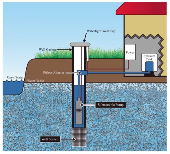
What is a well?
To access groundwater, a hole is drilled (modern wells are drilled, not dug) until water is reached. A well is constructed within that hole, usually in accordance with state regulations by a licensed water-well driller. The well itself has multiple components which include casing or the solid pipe that lines the hole and spans the sediment and rock layers that are not of interest; grout that seals the annular space between the solid pipe and the drilled hole; a screened interval near the bottom that allows water to flow in from the water-bearing layer being accessed, and a gravel pack which fills the annular space around the well screen to maintain access to the groundwater while keeping sediment out of the well. In addition to specifying where, how deep and in what aquifer(s) a well is constructed, state well code may also require that a report be submitted regarding well construction. Other permitting requirements may regulate how much groundwater is used on a daily or yearly basis.
Well-log data is important to the state because it allows a better understanding of the local conditions (geology and hydrogeology). It can be used with other well logs to map the geologic layers and, if needed, be used to model potential well interference and project long-term impacts from pumping.
Groundwater monitoring
Groundwater monitoring is a fundamental part of understanding how surface water and groundwater are connected and how groundwater pumping impacts long-term supply. Decades-long groundwater trends are also important in determining the response of the aquifer to climate and creating models that assist county and municipal planners in developing groundwater protection and management plans.
Maintaining funding for groundwater monitoring requires political will, which relies on the ability of the groundwater manager to communicate the importance of the work. So, the information used to make decisions about groundwater as well as the limits of those data need to be communicated effectively to both technical and non-technical audiences.
Groundwater models
It is impossible to know all the variables impacting groundwater because natural systems are large and complex. Reduced complexity models are commonly created to explore the sensitivity of the natural systems to changes in pumping and recharge. Groundwater scientists may understand the sensitivity of groundwater models to unaccounted-for withdrawals, or be comfortable with limited data at certain depths, but community members with the desire for the most accurate predictions may not understand how a model can be built to represent a system with limited data.
Community members may need to be brought along as models are created. The models should be built to address their questions as much as possible. Iteratively exposing stakeholders to models as they are built has proven more successful than presenting a fully built-out model, especially when the model results suggest that public sacrifices may need to be made. It is also critical to communicate which variables are the most sensitive, the level of certainty or uncertainty in the model, and how models should and should not be used.
Knowledge-sharing and communication
Policy, science and law must all be synthesized and translated for a non-technical audience. Non-specialists do not have time to think about these complex topics, resulting in them not being well understood in groups with mixed experience.
Be willing to educate those who show up in bureaucratic processes and explain technical language. Be willing to listen to and hear the local experience and how the impact is felt despite the intention of the action. Be willing to act in partnership with local knowledge and energy, and to invest in the process. After the needs of a community are explored, and relationships developed, groundwater technical experts can design their studies and models to address those specific concerns. Iterative engagement is both a strategy and a tool in the ongoing work of groundwater governance.
It is a best practice to increase public awareness of groundwater and how it connects to surface water. Create informational content to effectively outline key water issues. Host easy-to-attend webinars that are recorded and can be disseminated afterward to reach diverse and large audiences. This can be followed with more nuanced messages about the purpose of gathering groundwater data (monitoring) and synthesizing it with climate and pumping data using models.
Increasing public confidence in science and data collection could be further strengthened through community-based research and community participation in water events. For example, community members may build understanding and awareness through events that provide services like a well-maintenance or water-testing clinics. Overall, improving trust and working relationships in the community at large is fundamental.
City administrators who have limited staff may not know what questions to ask, of whom, or even whether to question the long-term sustainability of their groundwater. In the absence of direct outreach with specific regional information from the state or county, an NGO or academic partner can help under-resourced communities put groundwater sustainability issues in context. Transparency and coordination of technical data and knowledge production between entities in a region also promotes confidence in spending on data management and planning efforts. Expanding groundwater conversations beyond technical managers and to a city’s, state’s or Tribe’s economic development agency is a way to ensure that business development and growth are mindful of groundwater availability.
Note: This information is part of a series of groundwater governance topics Freshwater explored during an 18-month project, which culminated in the report: Towards Collaborative and Equitable Groundwater Governance in EPA Region 5.
This is very well written and insightful