…besides the water level that is.
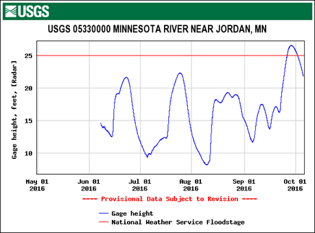 If you’ve been paying attention to the big brown river, or just the weather across the southern part of the state this summer, you know it has been a big-water year. The river finally reached flood stage in late September but it was a yo-yo summer with three high flow periods prior to the flooding. Almost all regions of the state have above average flow for this time of year thanks to the increase in large rain events that seem to be the new normal for Minnesota.
 All this rain increasingly heads straight to our rivers since we are a society that doesn’t like puddles or soggy fields. We use storm drains in cities and ditches and tile in almost every field in the Minnesota watershed to hurry water on its way. So even without an increase in precipitation, the effect of efficient drainage on rivers is shows up as the yo-yo pattern in the Minnesota River hydrograph.
To top it off, we have altered an often overlooked part of the hydrologic cycle—evaporation and transpiration by plants. Switching from perennial plant cover to annual crops has affected how much water gets evaporated and when. Soybeans have small leaf area and corn, very large, at least for some of the year. The bigger the leaf, the more potential to transpire water. Corn sweat is what I heard it called recently and yes, maybe that is a more catchy way to describe it than evapotranspiration. Read more.
The overall effect is to have reduced levels of water returning to the atmosphere during the bare-field and small-leaf season—so more water to the streams; and a lot more water returning to the atmosphere in August, leading to summer humidity and a new, second peak in convective storms in Minnesota.
So the conclusions in a recent report funded by the Legislative and Citizens Commission on Minnesota Resources should not be surprising for us—the rivers are responding to all these changes to the hydrologic cycle. The increase in precipitation, the more efficient delivery of water and reduced evapotranspiration are making the rivers bigger and the Minnesota River is doing this the most.
“Of the five river basins analyzed, the Minnesota River Basin has experienced the largest stream flow changes compared to the other four basins…on average, magnitudes of the 1-, 2-, 5-, 10- and 25-yr floods increased by about 20 to 30%. The likely cause for these changes is not only the change in precipitation (climate) but also the change in agricultural practices.” (Source)
The bigger river flows are widening the Minnesota River and its tributaries, causing on average 6” of river bluff retreat per year when averaged over 13,000 parcels in the Minnesota River watershed. That’s 80 acres a year, lost. The sediment that is eroded clouds the water, which has consequence for aquatic life because it affects light penetration, the food chain that depends on photosynthesis, and clogs the filtering mechanism of organisms like mussels. The coarser sand grains settle out where the river slows—at about half an inch a year in the reach between Chaska and the confluence with the Mississippi. This fills the channel, causes more frequent flooding, lowers the freeboard on levees around towns, and results in more frequent dredging for the navigable portion of the river.
So what’s a river to do? Turn off the water. We can’t change the weather but we don’t have to just sit by and watch all that soil (and the phosphorus that attaches itself to soil particles) flow downstream. That is money down the drain. An increase in water storage in each tributary watershed with a focus on the headwaters areas, will help dial back the flows to more manageable levels. This will save cropland along the rivers and the headaches created for the downstream neighbors on the receiving end.
Water storage can be short or long term. What is needed is to reduce the big pulse of water that hits a stream during a rain or snow-melt event by increasing perennial plant cover, restoring wetlands, undersizing culverts, and anything else that slows it down and allows more water to filter into the ground or return to the sky.
— Carrie Jennings, research and policy director